Large masterplanned communities rarely fail because of a lack of ambition. They fail when early assumptions collide with reality, especially environmental reality. When environmental constraints are missed, everything that follows becomes more difficult. Land use yields are reduced, infrastructure corridors move, approvals stall, budgets blow out, and client trust erodes.
Parkside City is a good example of why constraints-led planning matters in Papua New Guinea. MC Infrastructure (MCI) was asked to step in after a previous consultant did not adequately recognise key environmental constraints. The result was a plan that could not responsibly progress. Before we could talk about lot numbers or staging, we needed to re-establish what the site would actually allow.
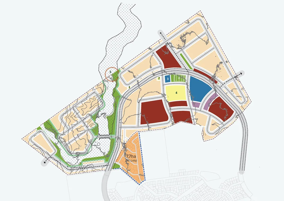
MCI's first step was to treat the site as a system, not a blank canvas. They compiled a composite view of constraints and informants, then tested the masterplan assumptions against them. Several factors immediately changed the shape of what was possible. The eastern low-lying Waigani swamp area carried overlapping sensitivities including flooding behaviour, soil instability, and ecological values. A network of rivers and creeks, with riparian corridors and low-lying vegetated land, functioned as both natural drainage and an ecological spine. Periodic flooding across parts of the site was not to be a minor inconvenience; it was a design driver.
These constraints had real planning consequences. Buffers were required. Certain areas needed to remain as green infrastructure rather than developable lots. Setbacks and careful interface treatment were needed near environmentally and culturally sensitive areas, such as on the northern platform at the edge of the National Capital District (NCD) boundary.
Existing infrastructure also shaped outcomes. A sewerage treatment pond near the swamp required retention, and appropriate setbacks. Airport approach height limits influenced built form opportunities. MCI shifted the future town centre west, to allow higher density whilst not interfering with aircraft safety. Power line easements and other encumbrances needed to be protected. Informal settlement interfaces required careful planning and sequencing.
This is what constraints-led planning looks like in PNG. MCI started by mapping the non-negotiables, then designed the city around them. They used waterways, riparian areas, and flood-prone land as an organising framework for open space and movement, rather than trying to “solve” them late with expensive engineering. MCI established a road hierarchy and trunk infrastructure routes that respect drainage patterns and avoid pushing risk downstream. They planed lot staging that protects compliance and constructability, and allowed the client to be flexible in their design and remained accountable to market needs in the future development pipeline.
With that foundation, MCI reframed Parkside City into a masterplan that could be delivered responsibly. The scope included an urban plan for more than 1,500 residential lots, alongside commercial and light industry areas. They progressed the civil design and supervision, aligned the technical work with environmental requirements, and prepared environmental compliance documentation packages and assessments to support approvals.
High-profile projects also require clear communication. MCI's work was presented to the NCD Governor Powes Parkop and PNG Prime Minister James Marape, ensuring decision-makers could see how constraints were being managed and how risk was being reduced. Parkside City has since been recognised as a project of national significance in PNG, which reflects both its scale and the importance of getting the fundamentals right.
The lesson is simple. In masterplanned communities, what goes wrong first is usually what was not seen first. Constraints-led planning is not a limitation. It is how responsible development becomes possible.